|
Land Preservation News from the Maine
Chapter of The Nature Conservancy
TROUT MOUNTAIN
Trout Mountain is the centerpiece
of a million dollar/3,564-acre purchase from Great Northern Paper.
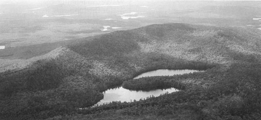
The mountain rises above nearly a dozen ponds, including Twin
and Logan Ponds which provide some of the state's most intact
native brook trout habitats.
Nestled against the southeastern
edge of Baxter State Park, the property provides stunning views
of Mount Katahdin seven miles to the north. In the tract's northeast
corner, an unusual washboard of sand ridges and wetlands characterized
by open sedge meadows and speckled alder swamps attract an array
of wildlife including beaver and moose, otter and mink. These,
along with old-growth forest remnants, pristine ponds, spruce-fir
slopes, red pine shores, kettlehole bogs, cedar-lined lakes,
steep hardwood slopes, cliffs and eskers only begin the list
of features on this largely unroaded expanse.

An aerial view of the Nature Conservancy's new Trout Mountain purchase. Photo by Chris Ayres.
On the
fringe of Baxter State Park, and just north of Millinocket, the
land comes with a history of recreational use. We look forward
to working with sportsmen, snowmobilers and others in maintaining
many traditional uses.
MOUNT AGAMENTICUS
From the shores of York Pond
in Eliot to the pocket wetlands of the Tatnic Hills in Wells,
the conservation efforts of The Mount Agamenticus Challenge protect
one of Maine's most important ecosystems. In just a year and
a half since the Mount Agamenticus Challenge was launched, the
Conservancy, Great Works Regional Land Trust and York Land Trust
have conserved some 500 acres of land in the greater Mount Agamenticus
region. With 650 more acres in the pipeline, we are making rapid
progress toward our goal of conserving 7,000 acres over five
years - nearly twice the land in conservation there today.
Our strategy is a simple one -
focus on expanding large tracts of conserved land in areas where
the most valuable plant and wildlife habitat exists. One of these
areas is York Pond in Eliot. With its Pitch Pine bog and Leather
Leaf shrub swamp, the York Pond area has one of the most significant
wetland complexes in the greater Mount Agamenticus region.
The most recent purchase here secures
an important tract near York Pond. Acquired from Eastbrook Timber
Inc., this property adds 91 acres to an existing wildlife area
managed by the Maine Department of Inland Fisheries and Wildlife,
and completes the core of 535 acres of continuous conservations
lands protected by the Town of Eliot, Great Works Regional Land
Trust and the Maine Department of Inland Fisheries and Wildlife.
Other Mount Agamenticus Challenge
purchases over the last year include four tracts in York. Two
of the parcels are now owned by York Water district while the
Conservancy holds title to the other two tracts.
The Mount Agamenticus Challenge
has secured several parcels in the Chick's Brook area of South
Berwick with additional parcels in the area under contract. This
unique area with its jagged bedrock cliffs and rocky, swift flowing
stream is home to a small population of swampdarters, a species
of fish at the northern limit of its range in Southern Maine.
It is also home to other rare species like Blandings and Spotted
turtles.
The initiative is making great strides
to conserve lands that bridge large conservation areas as well.
One such project is slated to close mid-May - the purchase of
a 106-acre parcel off of Ogunquit Road in York and South Berwick
that will help connect the York Land Trust's Hilton Preserve
with land owned by the Maine Department of Inland Fisheries and
Wildlife. The Mount Agamenticus Challenge also has a purchase
option on land in the Bell Marsh area of York for up to 250 acres
of prime habitat, forests, and wetlands that link York and Kittery
Water District lands with lands conserved on and around Mount
Agamenticus. These last two tracts formed part of a large 500-acre
deal with Eastbrook Timber, Inc. which worked with the Conservancy
to reach a conservation outcome.
While the momentum behind this project is building, the development
pressure in the greater Mount Agamenticus region persists. We
are in a race against time - even as we meet with landowners
and close on land deals, we are often just in time to prevent
development of the area's magnificent forests and farms.
In the end, it is the strength
of the partnerships created through the Mount Agamenticus Challenge
that will define the success of this project. To make it work,
we will need continued collaboration between private organizations,
state agencies, municipalities, water districts, and individuals
who share an interest in protecting this important resource.
|
